Tech Made Simple

Hot Topics: How to Fix Bluetooth Pairing Problems | Complete Guide to Facebook Privacy | How to Block Spam Calls | Snapchat Symbol Meaning

We may earn commissions when you buy from links on our site. Why you can trust us.

author photo

Get These Apps Before Your Next Road Trip

by Suzanne Kantra on June 02, 2023

Updated on 6/2/2023 with new app recommendations.

Memorial Day Weekend marks the beginning of the summer road trip season, and it's going to be a busy one. According to a Forbes survey on 2023 travel plans, 42 percent of respondents said they are planning a road trip this year – that's in addition to those traveling to destination travel. Loading up on the right apps to help find cheap gas (or EV charging), bathrooms, and sightseeing opportunities, as well as apps to steer clear of speed traps or traffic, is essential. I have been using all of the following apps for months if not years, and all have come in handy.

Of course, remember to stay safe and don't try to use your phone while you're driving.

How to find cheap gas and other basics

Three screenshots of iExit: From the left, the first screenshot shows the home screen with the option to select a highway or select nearby gas stations, food, and hotels. The second screenshot shows a listing of exits for route 278 and the gas stations found at each exit, along with pricing. The third screenshot shows an exit listing on route 278 with the fuel, food, and lodging options, along with gas prices and ratings for the restaurants.

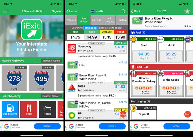
If you're traveling on a major highway, iExit (Free in App Store and Google Play) is a great resource to find amenities available at upcoming exits. There's information on restaurants, gas stations, grocery stores, hospitals, hotels, and more. For gas stations, you can select your fuel type (unleaded, mid-grade, premium, or diesel) and see pricing by gas station at each exit (price data is updated daily by OPIS).

Once the app finds your location on the highway, it will show you upcoming exits along with icons to represent amenities and how far away each exit is. Then for each service, you can see just how far you'll have to travel off your route – much better than those icons on the highway signs. If you're planning a trip, you can select a highway to plan out your stops along the way.

If you own an electric vehicle, the PlugShare App (Free in App Store and Google Play) would be my pick. While I don't own an electric vehicle, I evaluated the options and read the reviews, and PlugShare consistently receives high marks for its easy-to-use interface and the fact that it doesn't favor any charging network. Plus, I like the fact that you can add your vehicle, and only compatible charging stations will appear as options.

Three screenshots of the WeeWee app: From the left, the first screenshot shows a map with toilet paper icons indicating the presence of a public restroom. The second screenshot shows the filter you can apply to search: Baby Station, Special Needs, Family Bathroom, and Gender Neutral. The third screenshot shows the list for the John Jay Park bathroom with a rating, the hours it is open, the address, and the option to play one of the WeeWee Symphony sounds Thunder story, Zombie, Police.

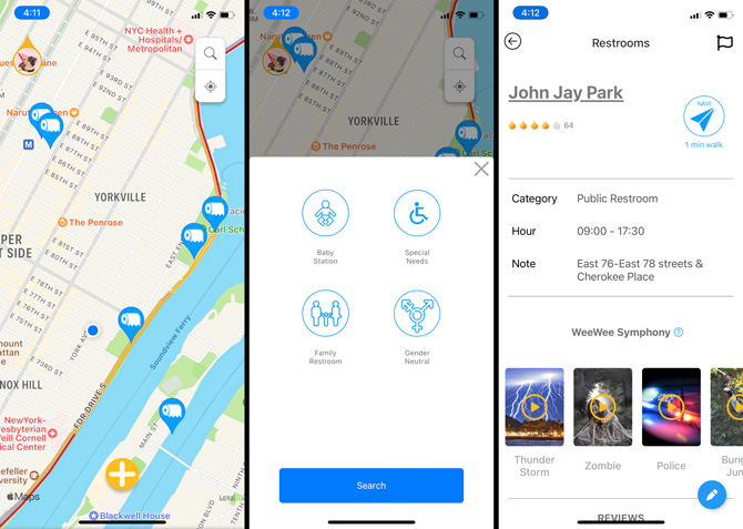
If it's a bathroom you're after, try WeeWeeFree (Free in App Store and Google Play). WeeWeeFree has restroom ratings and you can search by features, like baby station, family restroom, gender neutral, and special needs. Shy about using a multi-stall bathroom? The app also comes with "WeeWee Symphony," which are sounds to cover up any noises you may make.

Traffic, road hazards, speed traps and tolls

Waze appThree screenshots of the Waze app: From the left, the first screenshot shows three possible routes on a map along with the time to destination and the toll you will pay. At the bottom of the screen is a start drive button. The second screenshot shows a pop-up window over a map with the time you will arrive at the destination, the drive time, and the miles to your destination. Below you see your destination address, the toll, and a timeline showing a 10-minute traffic delay. Below you can see an option to find the best time to leave. Finally, you see buttons for Routes, Share drive, Overview, Stop and Resume at the bottom.

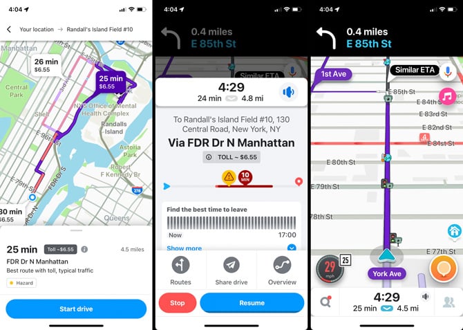
No one likes getting stuck in traffic or getting a ticket. Thankfully, you can use an app to get alerted before you get stuck. Waze (Free on App Store and Google Play) uses crowdsourced data to not only find a faster route for your drive, but also includes alerts to speed traps, red light cameras, and road hazards provided by other users as well. With a large user base, this app is as good as real-time traffic reporting gets. Over the last six months of testing Waze versus Google Maps, I found that Waze consistently beats Google Maps when it comes to identifying problems on the road and suggesting new routing in most situations. The only exception would be if you're in a city, like New York, where I've found Google Maps to be better.

Three screenshots of the TollGuru app: From the left, the first screenshot shows a map showing the fastest route from New York City to Bates College. At the top, there are three buttons: Cheapest, Fastest, and Others. Below you see how much more the fastest route is than the cheapest route. Below are the estimated fuel cost, travel time, and miles. At the bottom of the screen are the Home, Compare, Info, and Navigate buttons. The second screenshot compares the routes with the cost for tolls broken out from the total cost for the cheapest and fastest routes. The third screenshot shows the cost for E-ZPass versus the cost of Tolls by Mail for each toll.

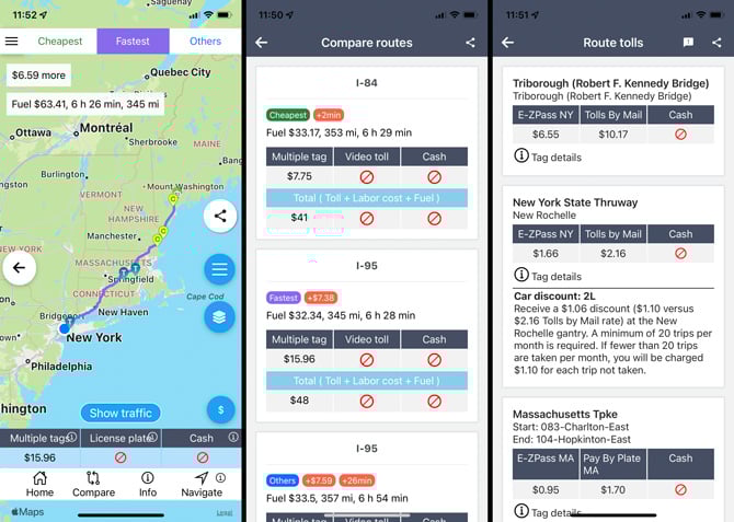
If you're concerned about tolls and gas adding up, check out TollGuru (Free on App Store and Google Play). You can calculate tolls and gas together for a wide range of vehicles, including cars, motorcycles, RVs, and SUVs towing a trailer, among others. Input your car make and model year and expected gas price for the best accuracy. You can plan routes in the U.S. and Canada.

Sightseeing

Three screenshots of the Roadtrippers app: From the left, the first screenshot shows a map with a route highlighted, multiple icons for activities and sights, and a large 3. Below the map, you see a picture of Hampton State Beach in Hampton, NH, with a large 3 next to it. In a green bar, you see Bates College trip. The navigation at the bottom of each screenshot is Nearby, Map, Guides, and Profile. In the second screenshot, you see the listing for Hampton State Beach with the option to Add to trip and Navigate. You can see reviews and photos and hours of operation, the address, phone number, and website. In the third screenshot, you see a list of all of the Bates College road trip stops, along with the miles between each stop and the amount of time it will take between stops.

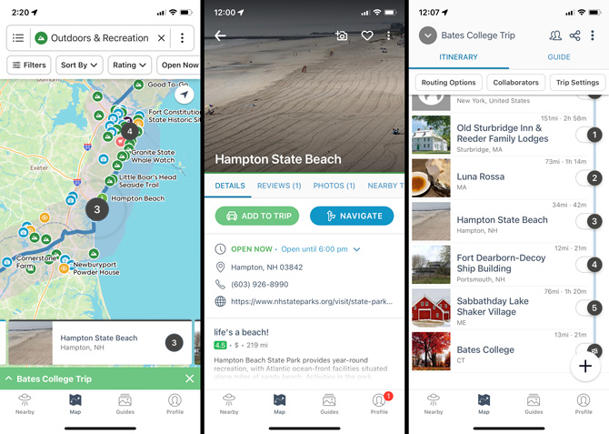
Don't want to miss any sightseeing gems on your trip? Enter your starting point and your destination, and the Roadtrippers app (Free in App Store and Google Play) will find you interesting places to stop in between. Pick from categories such as Attractions & Experiences, Outdoors & Recreation, and Sights & Landmarks, and you'll see places pop up along your driving route. You can read up on each attraction and choose to add it to your trip. The free version of the app only lets you add 5 stops. Upgrading to Roadtrippers Plus ($35.99 per year) removes adds, lets you store up to 150 waypoints on your route, see traffic, and view maps offline. If you're driving an RV, you can receive RV-friendly routing and safety alerts. And, you won't see any ads.

Where to stay

Three screenshots of the Trip Advisor app: From the left, the first screenshot shows the home screen for the city of Portland, Maine, with the menu options: Overviews, Hotels, Things to do, and Restaurants visible. Below is a picture of a lighthouse on the coast of Portland. In the second screenshot, you see the Hotels tab selected with the results of a search for a two-person stay from May 27-29. The results are sorted by best value. The Embassy Suites by Hilton Portland, Maine, is listed along with a user rating, price per night, and a link to the hotel website. The third screenshot shows the Things to do tab with listings for Ways to tour Portland, including The Real Portland Tour: City and 3 Lighthouses Historical Tour. The price of the tour is listed.

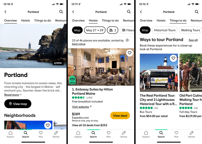
If you don't like to be locked into staying in a particular hotel or town as you travel, you can book your room while you're on the road. Trip Advisor (Free in App Store and Google Play) lets you search for hotels by city or zip code. Or, you can find hotels that are closest to your current location. The app pulls up the best value hotels first, helps you check rates, and tells you how many miles away they are or shows them on a map relative to your location. You can also filter hotel listings by traveler ranking, price, and distance to the city center.

If you're going to be staying in a major city, also check out Hotel Tonight. I have successfully used the app for city stays and consistently found high-quality hotels for low prices.

Where to eat

Three screenshots of the Resy app: From the left, the first screenshot shows a list of restaurants in New York City sorted by the Vegan Gems filter. For each restaurant, you can see the restaurant name, available reservation times, star rating, distance from your location, and an icon that indicates how expensive the meal will be. One restaurant has a button that says notify with a bell icon. The second screenshot shows a list of restaurants in Portland, Maine. The reservation buttons have locations, including bar, high top, indoor, indoor bar, BBQ, and outdoor. The third screenshot shows the restaurant's listing page with the star rating, type of cuisine, expense rating, reservation availability buttons, an overview of the restaurant, and a need-to-know section with additional information.

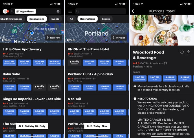
If you've found the perfect place but need a reservation, Resy (Free in App Store or use Resy.com for Android phones) is the place to go. Using the app, you can search for local restaurants with open tables when you're planning on stopping for a meal. If you know where you want to eat, you can search for a specific restaurant – but you can also browse by location and schedule or filter the list using one of the "Collections," which include categories like Top Rated, James Beard Nominees, Vegan Gems, and Best of Brunch. When selecting a reservation, you can choose your type of seating – dining room, outdoor, bar, patio, etc. If a table is not available, you can select the "Notify" option, and the app will let you know if a table opens up (yes, I've used it, and I've gotten a table).

Parking

Three screenshots of the Best Parking app: Frome the left, the first screenshot shows the home page of the app where you input your location,  the address near where you want to park, and the hours you want to park. The second screenshot shows a map with icons for the garages that show pricing and lines on the streets that show red for no parking, light blue for free parking, and dark blue for metered parking. The third screenshot shows a garage listing with the address, distance from your current location, amenities (covered and valet for this garage), fee for large vehicles, a note that you can extend your reservation with the app, and pricing. There is a button: Continue to book.

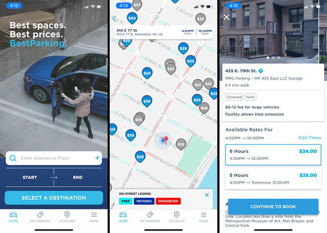
When arriving in a strange town, finding parking is going to be your first task. The Best Parking app (Free on App Store and Google Play) will show you available garage and street parking either immediately around you or anywhere you search on their map, along with the cost for each one. You can filter your search by either garage or street parking, and then further refine your search by features like accessible spaces, valet parking, on-site security, and electric vehicle charging, among others. Once you find a garage, you'll see any extra fees for large vehicles, the hours of the garage, and whether you can extend your reservation through the app.

Now that you're loaded up on essential road trip apps make sure you have the tech you need for your car safety kit.

[Image credit: couple driving in convertible via BigStockPhoto, iExit, Google, Toll Guru, Roadtrippers, Trip Advisor, Resy, Best Parking]

For the past 20+ years, Techlicious founder Suzanne Kantra has been exploring and writing about the world’s most exciting and important science and technology issues. Prior to Techlicious, Suzanne was the Technology Editor for Martha Stewart Living Omnimedia and the Senior Technology Editor for Popular Science. Suzanne has been featured on CNN, CBS, and NBC.


Topics

Tips & How-Tos, Travel & Entertainment, Car Tech & Safety, Travel, Mobile Apps, Android Apps, iPhone/iPad Apps


Discussion loading

gravatar

From Canadian_user on May 15, 2014 :: 10:26 am


Even better than google maps is an app called “Waze”. Free on iTunes, not sure about Google Play. Shows you real time traffic updates, option for alternate routes, shows where there are cops, whether they are hidden or in plain sight, red light cameras etc etc…

Much better and easier to use than Google Maps app IMO.

Reply

gravatar

From neminem on May 18, 2014 :: 4:08 am


I was also going to post about Waze - I don’t know why anyone would ever recommend Google Maps over Waze… nor do I know how I managed to live so long *without* Waze. I learned about it a few months ago, now I use it anytime I’m driving more than a few miles. There’ve been a few times it’s directed me to do things that made me think it was going crazy and sending me who knows where… every time, after doing what it told me to do, it became clear just how amazing a job it can do at redirecting you past as much traffic as possible by sending you down alternate routes and back.

(And it is also free on Android, as that is what I use.)

Reply

gravatar

From Google User on February 29, 2016 :: 8:52 am


Well they would recommend the source data (Google Keyhole) over its crappy subsidiary which seems to be aimed at the one demographic that doesn’t drive, tweens with its unprofessional cartoonish interface.

Reply

gravatar

From Phil Conti on May 22, 2019 :: 4:59 pm


Ditto your experience..she sends me wherever I shake my head in total belief afterwards in amazement…she got me home three different ways I never would have done or thought…successfully! She rocks!!

Reply

gravatar

From Cat B on April 23, 2021 :: 4:39 pm


Waze is an amazing GPS app.  It fosters a lovely community spirit, with wazers helping other wazers with quick alerts about road hazards, accidents, speed traps, detours, etc.  Waze is almost 100% spot on accurate, even driving all over Italy, with one rather embarrassing hiccup… In Sorrento, Italy, Waze sent us up a progressively narrowing road meant for horses and Vespas, not even the smallest of cars.  15 minutes after renting our little Fiat, thanks to Waze’s glitch, the road closed in on us and we nicked the side mirror.  Otherwise, perfect navigating.

Reply

gravatar

From Google User on February 29, 2016 :: 8:49 am


Actually Waze with its child like cartoonish interface is far inferior to Google’s interface which uses the same Keyhole data as Google is also the parent company of Waze

Reply

gravatar

From Barbara McKenzie on May 15, 2014 :: 4:50 pm


Is there an app that shows upcoming rest stops along highways?

Reply

gravatar

From Cynthia on December 04, 2019 :: 12:15 pm


Yes, its called ALLSTAYS

Reply

gravatar

From Pam on October 20, 2014 :: 7:44 am


What about privacy issues with Waze?

Reply

gravatar

From Avi on October 20, 2014 :: 8:36 am


What privacy issues? Bes to contact them for any concerns I suppose…

Reply

gravatar

From Google User on February 29, 2016 :: 8:56 am


They can be contacted at the Googleplex in California

Reply

gravatar

From Google User on February 29, 2016 :: 8:53 am


They are owned by google so your just as insecure as you are with google

Reply

gravatar

From Jojo mojo on June 05, 2023 :: 4:14 am


Waze has the best privaxy

Reply

gravatar

From L A Graham on May 21, 2015 :: 11:52 am


I have an Amazon Fire phone.  I cannot use apps from Google OR iTunes on it - only apps in the Amazon App Store.  I realize the Fire phone has a small segment of the current smartphone market But PLEASE provide at least Some content for it.

Reply

gravatar

From Josh Kirschner on May 21, 2015 :: 2:27 pm


Many of the apps listed above - Google Maps, Waze, Gas Buddy, OpenTable - are available on Amazon. If something above interests you, it’s worth checking on Amazon to see if you can get it for your Fire phone.

Reply

gravatar

From L A Graham on May 21, 2015 :: 2:45 pm


Thanks so much.  Waze is in the AppStore at Amazon and installed with no problems.  My prior comment was prompted because the AppStore is Never mentioned as a source for the apps I see in the articles here; it Should be when an app is available there as well.

Reply

gravatar

From Sara on May 22, 2015 :: 11:22 am


The sightseeing and traffic one seems like they might come in handy the next time I travel. Awesome, thanks for listing these!

Reply

gravatar

From Lokesh Kumar on June 03, 2015 :: 9:07 pm


I think Urgent.ly is also an essential app for any roadside trip.

Reply

gravatar

From Ron Ablang on May 22, 2016 :: 8:40 am


I checked out the app on the Google Play store.  Looks like it doesn’t yet support Sacramento, CA so I’m sticking w/ AAA car care club and paying my $150/year.

Reply

gravatar

From Paul on August 12, 2017 :: 9:22 pm


That would be cool if AAA has an app…used to love how they marked up a map so you know where the cool stuff was along your route.

Reply

gravatar

From Mike W on May 17, 2019 :: 12:01 pm


AAA Motor Club does have a Roadside Assistance with GPS Locator for your Phone.

Reply

gravatar

From Sarah on December 27, 2017 :: 12:46 pm


I will suggest adding an app that calculates tolls and gas costs for the road trip. TollGuru is a neat trip-planning app that allows you to quickly look up the price of all toll bridges, roadways, and tunnels from start to destination. It adds up the costs of gas and toll to show you the cheapest, fastest, and compromise routes.

Reply

gravatar

From Biplab Poddar on January 27, 2018 :: 8:05 am


Thanks for sharing this. I am a travel. I can relate to you.Travel is fatal to prejudice, bigotry, and narrow-mindedness, and many of our people need it sorely on these accounts. Broad, wholesome, charitable views of men and things cannot be acquired by vegetating in one little corner of the earth all one’s lifetime.
People often have a theme that they base their worldly travels on, but how about a mental mantra for your travel? Out of a cheerleading event that consisted of our family shouting supportive words at our daughter who was attempting to kill a rather monstrous spider that the rest of us were too chicken to get close to, came this great quote, “If you don’t think, and you just do….then it’s done!”

This quote came back to haunt me when on vacation in Seattle. I thought it would be a great idea to take the kids on the Seattle Great Wheel, the ferris wheel overlooking the ocean, but as we approached it, I realized how high it went and immediately panicked! Just as I had decided to put the kids on it on their own, my daughter says, “Come on dad…If you don’t think, and you just do….then it’s done!” What could I do at that point?! She was telling me to stop thinking and creating more fear about the situation and just get on the thing!

Reply

gravatar

From Peter J. Bertini on May 27, 2022 :: 7:01 pm


@ Travel With GozoCabs

Just say it dude.  Just say that you quoted Rick Steves.

Just say it.

Reply

gravatar

From Trip Rothschild on May 16, 2018 :: 10:49 am


You missed my favorite road trip resource: roadfood.com.
It lists and reviews one-of-a-kind restaurants that showcase the rich local cuisines still found throughout the country.

Just used it with great success for a cross-country car ferrying drive - in Austin (BBQ), Shreveport (Cajun seafood), Chattanooga (burgers), Shenandoah Valley (Virginia ham) and Scranton (“white pizza”).

Reply

gravatar

From Tony Everhardt on August 21, 2018 :: 10:49 am


It’s called Rest Stops. It’s a blue app with a white winding road on it with 5 stars. 1 of the stars being red.

Reply

gravatar

From evangelos carpodinis on November 25, 2018 :: 8:55 pm


driving on the highway. You get sleepy. Any App that will tell you the cheapest hotel in the area?

Reply

gravatar

From Gerald Plessner on February 14, 2019 :: 9:01 am


I have recently come across AnyFinder (anyfinder.info) and find it very useful. It works with OpenStreetMap and helps me to quickly find the major kind of POIs from their database. Only works online though.

Reply

gravatar

From Leo on May 31, 2019 :: 4:23 am


I see you included Tollguru as part of your presentation, but actually they have plagiarized Tollsmart’s concepts and ideas and have since been hiding from public. It is Tollsmart that is the original and best tolls calculator. Do check it out.

Reply

gravatar

From Niraj Singh on April 19, 2021 :: 7:20 am


Well, that’s a big thing that you are saying. Just checked both and found out TollGuru has much more coverage than Tollsmart and their app has a lot more to offer.

Not sure how someone plagiarized what wasn’t even there (wink). Look at their coverage.  Extending the same logic to mapping, I am sure you don’t think that every map provider is a copy of each other right?

Cut to chase, Tollsmart is good but TollGuru is just better. I am a user of their API and they update their toll charges every few minutes. Really fast I must say.

Reply

gravatar

From JFK on December 17, 2019 :: 7:04 am


Really without these tools travel is not possible in today’s life. I want to say thank you for this beautiful post. It’s really helpful for all travelers.

Reply

Home | About | Meet the Team | Contact Us
Media Kit | Newsletter Sponsorships | Licensing & Permissions
Accessibility Statement
Terms of Use | Privacy & Cookie Policy

Techlicious participates in affiliate programs, including the Amazon Services LLC Associates Program, which provide a small commission from some, but not all, of the "click-thru to buy" links contained in our articles. These click-thru links are determined after the article has been written, based on price and product availability — the commissions do not impact our choice of recommended product, nor the price you pay. When you use these links, you help support our ongoing editorial mission to provide you with the best product recommendations.

© Techlicious LLC.