Tech Made Simple

Hot Topics: How to Fix Bluetooth Pairing Problems | Complete Guide to Facebook Privacy | How to Block Spam Calls | Snapchat Symbol Meaning

We may earn commissions when you buy from links on our site. Why you can trust us.

author photo

16 Surprising Things You Can Do with Google Maps

by Suzanne Kantra on August 02, 2023

Updated on 8/2/2023 with new features, instructions, and screenshots.

Google Maps has evolved a lot over the years, making the jump from our computers to our phones and adding a ton of cool features along the way. In fact, there are so many that we're sharing our favorite features, along with some hidden tips and tricks.

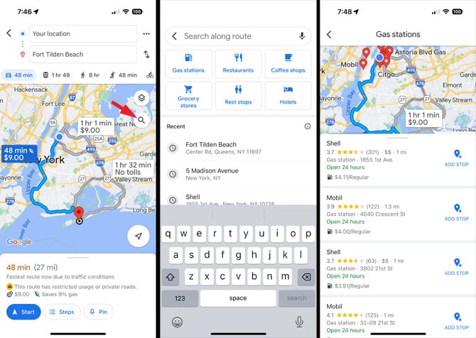
1. Add stops to your trip

When you get in the car for a road trip, you rarely go straight to your destination without stopping. You'll need to stop for lunch or gas or a bathroom break or a detour to visit a cool roadside attraction. Once you program in your destination, it's easy to add stops along the way. 

For stops after you've started your trip, you can tap the search icon and choose from “Gas stations,” “Grocery stores,” "Restaurants," "Coffee shops," "Rest stops," "Hotels" or to search. 

For planned stops, you can add stops after tapping the "Directions" button. Tap the search icon and choose from the same options – “Gas stations,” “Grocery stores,” "Restaurants," "Coffee shops," "Rest stops," "Hotels" or to search. The results will cluster around your starting point, but you can choose the search a different area by tapping the map, zooming in on the desired area, and selecting the "Search this area" button.

3 screenshots: 1st from the left shows a map with directions to a beach with the search icon pointed out. The 2nd screenshot shows a search bar to find locations with shortcut buttons for gas stations, restaurants, coffee shops, grocery stores, rest stops and hotels. The 3rd screenshot show the map with gas stations and the price per gallon next to them and the option to add stop.

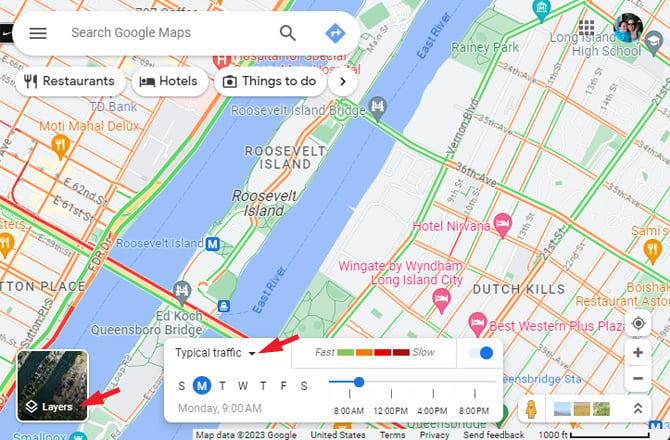
2. Check current and future traffic

If you want to check the traffic in your area, you need to turn on "traffic" by tapping on the layers button. For computers, you'll see a box with "Live traffic" and an upside-down triangle. Select the triangle, and you can choose "Typical traffic" to see what traffic will be like later in the day or week.

Screenshot of Google Maps showing the Layers button pointed out. You can also see a box that shows typical traffic for days of the week and time of day.

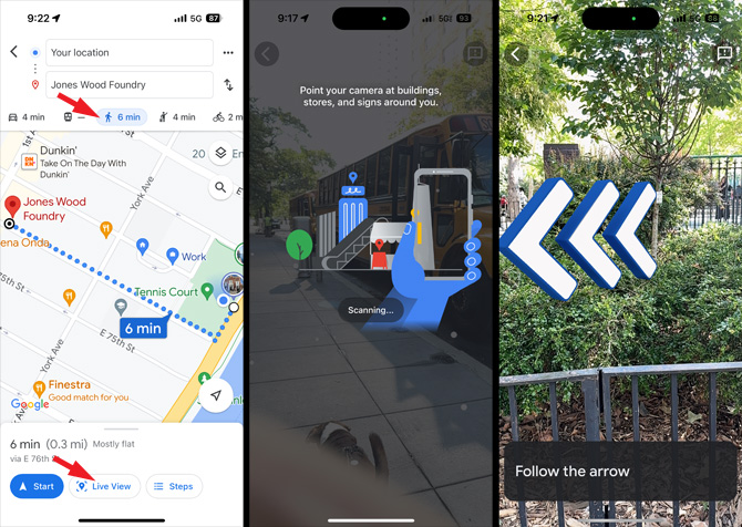
3. Use augmented reality to see where you should go

Are you all spun around? Not sure whether you’re supposed to make a right turn or a left because you don’t know what direction you’re facing? Stop wondering – with a quick tap of the compass in the top right corner of the screen while navigating will shift the map to face the same direction you are. Tap the compass again to switch back to the more traditional (but less useful) “North is up” view.

If you're walking, you can access Live View, a navigation mode that brings in a live image from your phone's camera and layers directions on top. Instead of tapping the "Start" button to begin navigating, select the "Live View" button. Tilt the phone up (as though you were taking a picture), and Google will determine where you're looking and point you in the right direction. Depending on where you look, you'll see where to turn or how far to continue in the direction that you're facing. When you want access to just the traditional map view, start walking or tilt your phone back down.

Google Maps screen shots showing the Live View Feature. In screenshot 1, you see a map walking directions from Your location to Jones Woods Foundry. The Walking directions and Live View icons are pointed out. In the 2nd screenshot you instructions to point your camera at buildings, stores, and signs around you so Google Maps can tell where you're looking.. In the 3rd screenshot you see three large arrows layered on an image of a park with the words Follow the arrow at the bottom.

4. Navigate through buildings

Need to find your seat in a large stadium or navigate to your favorite store at the mall or find your way out of a casino? You'll find maps of some venues, including airports, train stations, and malls, in Google Maps. And Live View works in some locations too. Live View is currently available in major U.S. cities, Zurich, and Tokyo, and coming soon to Barcelona, Berlin, Frankfurt, London, Madrid, Melbourne, Paris, Prague, São Paulo, Singapore, Sydney, and Taipei.

Google Maps screenshot of the interior of Caesar's Palace in Las Vegas. You can see the stores, hotel towers, restaurants and other venues.

5. Catch the last train

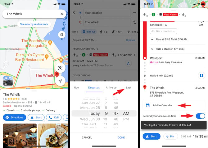
In many cities, mass transit trains don’t run all night – they stop running shortly after bars close. This can be a tough trip to plan if you need to make a transfer along the way. Fortunately, if you type your destination into Google Maps, choose the train icon, then “Depart at...” and then choose “Last” and “Done,” the app will show you the last trains and buses that get you where you need to go. You can even set a reminder to take the last train.

3 Google Maps screenshots. From the left, screenshot 1 shows a map a restaurant listing for The Whelk with the options for directions, start and call. Screenshot 2 shows the starting and end location, options for driving, public transit, walking, ride share and biking directions, with a listing of train options. Layered on top is a box with Now, Arrive by, Last, and Depart at underlined with a time/date wheel below to choose a departure time and date. Screenshot 3 shows public transit directions to The Whelk with the option to Add to Calendar and Remind you to leave on time pointed out. Below these options, you'll see when you'll receive your reminder.

6. Zoom one-handed

Most of us have been well trained to use the pinching gesture to zoom in on our smartphones. But there’s an easier way to zoom while using Google Maps: Just double tap the screen, and swipe up to zoom out or swipe down to zoom in. (Keep your finger on the screen after the second tap.)

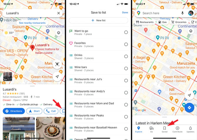
7. Save your favorite locations

Want quick access to all the locations you frequent most often, or just want to save information about a store or restaurant to review later? Maps lets you set Favorites by selecting the "Save" icon. Choose it as a "Favorites," "Want to go," or "Starred places" and it will show up on the map. When you want to consult your list, head over to the "Saved" icon in the bottom nav to consult your lists.

You can also save your home and work addresses to Google Maps to save time. When you search for an address, you can select "Label." This information interfaces with Google Assistant, allowing it to serve up real-time traffic updates to your phone before leaving for work in the morning.

Google Maps screenshots. From the left, screenshot 1 shows a map with a listing for Lusardi's restaurant below and the Save icon pointed out. Screenshot 2 shows a list of save places and a box at the top to create a new list. Screenshot 3 shows a map with Explore, Go, Saved, Contribute and Updates at the bottom with Saved pointed out.

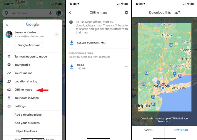
8. Create offline maps

If you’re traveling through the woods, mountains, or desert, there’s a good chance your phone will lose its data signal from time to time. Unfortunately, no signal means no maps – real bad news if you’re not familiar with the remote area through which you’re traveling.

Fortunately, Google Maps lets you easily save maps for offline use. Simply tap the mic and say “OK Map” to save the map that’s currently on your screen (for Android users). Or, select the menu (your profile photo in the top right) and choose “Offline maps,” and then "Select Your Own Map." You can access these saved maps by looking under “Saved.”

Google Maps screenshots: from the left, screenshot 1 shows the menu with Offline maps pointed out. Screenshot 2 show offline map option to select your own map and download your Home area. Screenshot 3 shows a map with a box that contains the map area to download with cancel and download underneath.

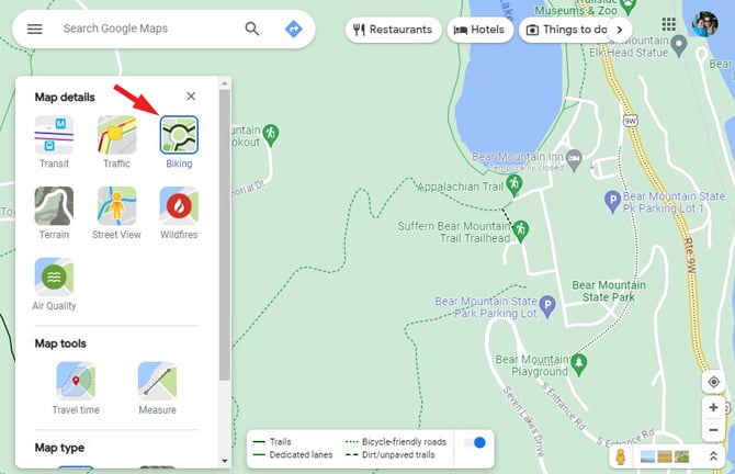
9. Check out hiking and skiing trails

Heading out for a day of winter sports and adventure? Google Maps has a wealth of skiing, biking, and hiking trail maps for a number of major destinations, including Snowbird, Big Sur, and Yosemite. You can see lift lines for ski resorts by searching for your favorite resort. For biking and hiking, bring up a map of the area, select "Biking" from the Layers menu, and zoom in to see the different trails. Don’t forget to save the maps for offline use before you go!

Google Maps screenshot showing Map details box with Transit, Traffic, Biking, Terrain, Street View ,Wildfires, Air Quality, and satellite options. Plus a legend box showing dark green for trails, lighter green for dedicated bike lanes, dotted green line for bicycle-friendly roads and brow for dirt/unpaved trails. At the top are options for searching for ATMs, Pharmacies, Parking, Transit, Attractions, Hotels, and Restaurants.

10. Check for wildfires and air quality

If you're traveling in an area prone to wildfires or likely to be impacted by wildfire smoke, Google has two map layers to help you spot trouble. Tap on the Layers icon and select "Wildfires" to see nearby reported wildfires. Tapping a fire icon will show the impacted area and when the data was last updated. You'll find links to local resources for help and information. Switching to the "Air Quality" layer will show air quality index readings from air quality monitoring stations nearby

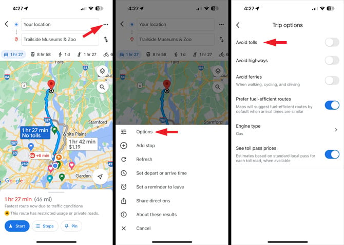
11. Avoid paying tolls

Looking to save a couple of dollars on your next drive? Instead of taking a costly toll road or bridge, you can tell Google Maps to only show you free access routes. Once you click on the "Directions" button, you can access the route options, including no tolls. Tap on the menu (triple dots) in the upper right corner next to you starting location. Select "Options" and then toggle on "Avoid tolls." Be careful, though: This could add a lot of miles to your trip!

3 screenshots: 1st from the left show a map of directions to Bear Mountain Trailside Museums & Zoo with estimated time for 3 routes plus the triple dots for the menu pointed out. The 2nd screenshot shows the map with a pop up showing options for route options (pointed out), add stop, set depart or arrive time, set a reminder to leave, and share directions. Screenshot 3 shows options to avoid highways, avoid tolls and avoid ferries with the option to remember settings.

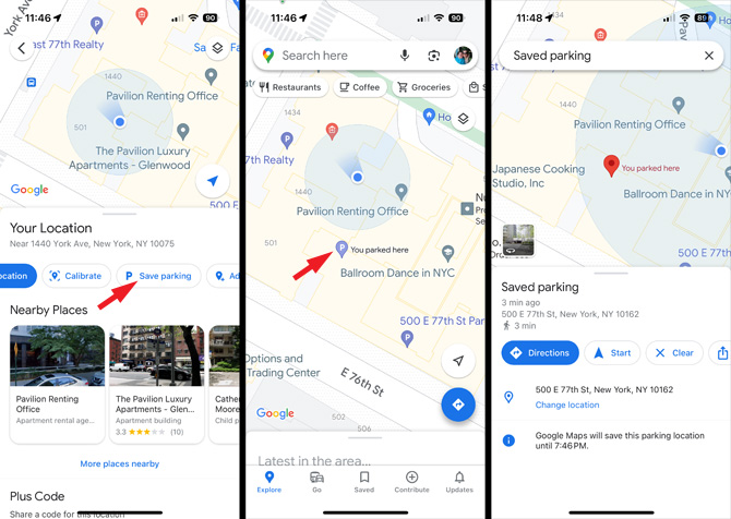
12. Remember where you parked

When you arrive at your destination, select the little blue dot that represents your location (a single tap, don't press and hold). Then you'll see the option to "Save parking." Once you've saved your parking spot, a parking icon (a capital P) will show up on your map. Tap the icon to bring up directions to your spot. For Android users, you can also leave a parking note (like the level in the parking garage) or a meter timer.

Google Maps screenshots: from the left, screenshot 1 shows map with blue dot signifying a person's location (below are Latest in Upper East Side and options for Explore, Go, Saved, Share, Contribute and Updates). In screenshot 2 there are options for Share your location, Add a missing place, Set as parking location (pointed out), Download offline map, Calibrate with Live Views and Cancel. In screenshot 3, there is a map with a large red icon entitle You parked near here and at the bottom a box entitled Save parking with options for Directions, Start and Clear. .

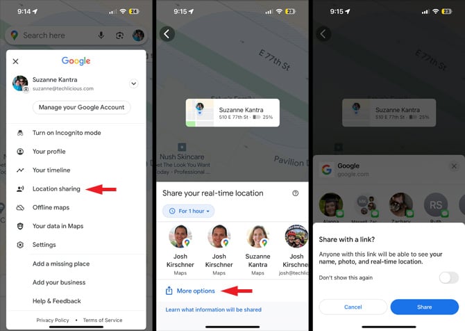
13. Share your location

There are times when it's beneficial to share your location with others. Maybe you want someone to know where you are when you go out on a run or see where family members are at an amusement park. With Google maps, you can choose to share your location for a specific period of time or "Until you turn this off." When you share your location with someone, they can see you on Google Maps, along with the time of the location information, and easily get directions to your location.

To share your location, tap your profile icon. Select "Location Sharing" and then tap the "Share Location" button. You can share your location with anyone's Google account. Or, you can select "More Options" to send a link through email or text that anyone can access.

You can also share your location while you're driving. Once you've started a trip, swipe up from the bottom, and you'll see "Share your trip progress" as your first option.

Google Maps screenshots: from the left, screenshot 1 shows Menu with the option for Location Sharing. In screenshot 2 A person's location and options for people to share your real-time location. You see location sharing set for 1 hours. At the bottom is a More options link. In screenshot 3, you can see you see a Share with a link pop up. It states that anyone with the link will be able to see your name, photo, and real-time location..

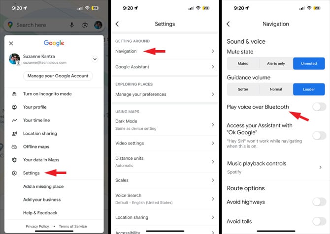
14. Hear voice navigation through your car speakers

If you have an older car and you've paired your phone to make and receive calls, you may also be able to get navigation guidance. Tap your profile icon, then select "Settings," then "Navigation" (under "Getting Around"), and then toggle on "Play voice over Bluetooth." Note that your car audio system will need to be set to play Bluetooth as the audio source, so you won't be able to listen to the radio and other sources. And if you have an old car that doesn't support Bluetooth as an audio source (in addition to making calls) you're out of luck.

Google Maps screenshots: from the left, screenshot 1 shows Google Maps menu with options for Turn on incognito mode, Your profile, Your timeline, Location sharing, Offline maps, Your data in Maps, Settings (pointed out), Add a missing place, Add your business, Help & Feedback. In screenshot 2 you see Settings options in sections. Under Getting Around, there are options for Navigation (pointed out), Ride services and Google Assistant, under Exploring Places there are options for Manage your preferences, and Your feedback about places, and under Using Maps there are options for Distance united, Scales, Voice Search and Location Sharing. In screenshot 3 there are options for Mute state (muted, alerts only and unmuted), Guidance volume (softer, normal and louder), Play voice over Bluetooth (pointed out), Access your Assistant with

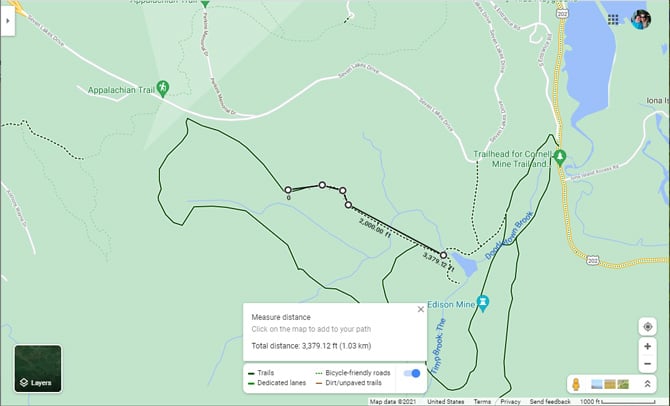
15. Measure distances between points

Want to know how far back the fence is on the ball field or calculate your run through the park? On the desktop of Google Maps, you can select a point by right clicking. Then select "Measure distance" from the menu. Add at least one more point, and you'll see the distance. To measure the distance between two points using the Google Maps app on your iPhone or Android phone, you first press and hold to bring up a menu, then add at least one additional point to see the distance. 

Google Maps screenshot showing 5 dots along a trail that show the total distance, plus a box entitle measure distance with a Total distance measurement.

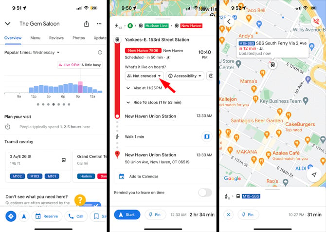
16. Check the busyness of transit, stores, restaurants, and more

If you're wondering how crowded the train will be or if a store or restaurant is really busy, the Google Maps app for Android and iOS will let you know. Google pulls in live location information if it is available or shows the projected busyness. You can even see how crowded trains and other public transit is and see when the next bus is arriving. 

Google Maps busyness screen shots. From the left, the first screenshot show Costco Wholesale list with Popular Time with a day of the week and downward arrow the change the day. Below is the Live time and busyness rating of a little busy and a graph showing how busy the location is throughout the day. The second screenshot show an itinerary for traveling to New Haven showing Pennsylvania Station at 5PM usually being as busy as it gets and New Haven State Street with a live rating of not too busy. In the 3rd screenshot you see a map with a bus icon and pullout bubble showing the bus line number, estimated time of arrival and an icon of one filled in person to show busyness level.

[Image credit: Screenshots via Techlicious/Google, phone in car via Smartmockups]

For the past 20+ years, Techlicious founder Suzanne Kantra has been exploring and writing about the world’s most exciting and important science and technology issues. Prior to Techlicious, Suzanne was the Technology Editor for Martha Stewart Living Omnimedia and the Senior Technology Editor for Popular Science. Suzanne has been featured on CNN, CBS, and NBC.


Topics

Travel, Phones and Mobile, Mobile Apps, Android Apps, iPhone/iPad Apps, Travel & Entertainment, Car Tech & Safety, Tips & How-Tos


Discussion loading

gravatar

From Poppy's Mom on July 19, 2017 :: 8:34 am


It seems that Google no longer is supporting the addition or updating of ski trails on its maps, so the information available may not be correct.

Reply

gravatar

From Suzanne Kantra on July 20, 2017 :: 12:53 pm


My contact at Google says the maps are continuously updated, including ski trails, and is interested in which areas aren’t being updated. Please provide the areas that are out of date, so I can share the information with Google.

Reply

gravatar

From Poppy's Mom on July 20, 2017 :: 1:19 pm


Suzanne - Can you send me a link or contact? We have multiple ski area clients that want to add their ski trails. I’ve searched for how to submit the ski trails to no avail - so I really appreciate your input!

Reply

gravatar

From Don Peacock on August 07, 2017 :: 9:22 am


Can’t wait to this

Reply

gravatar

From Jian Jian on August 10, 2017 :: 9:39 pm


Very good Performance

Reply

gravatar

From Robert on August 20, 2019 :: 5:45 am


Can l use Google Maps offline while out in the bay or running the intercoastal waterway?

Reply

gravatar

From Josh Kirschner on August 20, 2019 :: 8:06 am


In Google Maps, open the menu and you’ll see an option for “Offline maps”. You can choose what area you want to download, as well as the range of the map - the larger the rage, the more storage space will be required on your phone.

Reply

gravatar

From Cindy N-Stahnke on August 20, 2019 :: 10:32 am


My address is incorrect on the map and makes it impossible for me to have anything shipped to me (no door to door mail service) I’m hoping it can be fixed sometime?!

Reply

gravatar

From Josh Kirschner on August 20, 2019 :: 12:40 pm


In Google Maps, if you type your address and it isn’t showing up in the right place, you should see a menu option on the left (for desktop) that says “Report a problem on [XXX your address]”. Click that and you will have the option for “Wrong address - Fix details about this address, or where it appears on the map”. If you do that, it’s possible Google will fix it. Let us know how that goes.

Reply

gravatar

From Kumar on April 16, 2020 :: 1:18 am


Hellow,
 
Iam facing a problem in Google maps.
When I open maps it’s not showing my current location in android phone.it’s showing wrongly in some other place.

Tried methods,


Restart the mobile,

Caliberated compass,

Unistall app and installed again,

Checked with the recent updates.

Still iam facing problem.its not showing accurate location.

Please help me out to sought out this problem.


Thank you.

Reply

gravatar

From Pose 'n Post PhotoVideo on November 11, 2020 :: 1:09 pm


These features have been around for a while already. So no surprising things.

gravatar

From Jassim Anwar Ansari on October 19, 2021 :: 9:43 pm


Press the compass button

gravatar

From Linda on May 25, 2020 :: 2:27 pm


I tried requesting Google Maps to correct driving to my house a couple years ago. Their response “we will look into this request and get back with you.” I have never heard from them nor have the directions been corrected.

Reply

gravatar

From Linda C on July 02, 2021 :: 6:27 pm


I requested a correction to the driving directions to my house to Google Maps. It only took them about 3 years to make the correction but it finally happened earlier this year.

They were directing folks down a dirt road that ended at a wheat/soybean field with no driveway access to my house. Thank goodness it’s fixed. Now an ambulance or fire truck can find us first time instead of a 10 minute delay.

Reply

gravatar

From Roberta Wallace on January 07, 2020 :: 5:30 am


Why can’t I get a 15 mile radius of main town stations from Glasgow Central or queen street. This would really help me decide on a move where I could actually afford the fare’s and it didn’t take long to get to Glasgow to see family. I am getting older so will increasingly need family support but I want a quieter environment.

Reply

gravatar

From Myrick on April 20, 2020 :: 7:47 pm


not sure if upgrades did this or its my phone, but Google maps used to tell me point for point where to turn or what #exit to take. Now it just says exit in 1000 feet. Or turn left at next exit. Google maps used to say in 1000 feet take exit # 590A or something like at the next light turn onto Main St. It would give “specifics”. Now it just says very generic directions. Its confusing even when it says turn right at the fork and then you have an intersection and it says, after the fact what to do, before it would give specifics and tell you EXACTLY what to do before you get to a specific point and then say what srteet or what exit# to take. If there is a setting i have turned off tell me because ive tried to research if thats possible and havent been successful. I hate the generic directions because sometimes its not helpful!

Reply

gravatar

From Josh Kirschner on April 21, 2020 :: 11:09 am


With every update, Google is, no doubt, tweaking the type and level of navigation prompts. So if you’ve noticed a change, this is likely why. There is no way for a user to change the type or frequency of prompts in driving mode. You can choose to have more detailed instructions when walking in the Navigation Settings, but that doesn’t give you what you’re looking for.

Reply

gravatar

From Jory on May 09, 2020 :: 8:18 pm


Is there a way to keep to destination directions going once you have arrived.
For expamle say I am on a one way street and pass my destination so technically “arrive” and theres no way for me to turn around.

Instead of looking down at my phone and restarting the route is there a way to take the end arrival off of google maps so it just keeps giving me the directions.
I know this is a very strange request but believe me this would help me in the biggest way!

Reply

gravatar

From Miguel Mendoza on November 09, 2020 :: 3:53 pm


How a person has two different names same location on the Google maps when they share the location

Reply

gravatar

From Ming on February 01, 2021 :: 11:53 pm


I use Android and the results I get is only road distance by driving or walking, how can I find direct distance ?

Reply

gravatar

From Rod Walsh on February 18, 2021 :: 11:32 pm


I have 47 locations my team has to visit. Can I list those addresses and have Google Maps (or something else) identify a location where that team should stay to minimize average travel time or average distance? The two furthest points are about 300 miles apart, as the crow flies.
Thank you!

Reply

gravatar

From Josh Kirschner on February 19, 2021 :: 1:58 pm


What you can do is import the list of addresses into Google My Maps (https://www.google.com/maps/d/). From there, it would be pretty easy to visualize what location would be most centrally located for you.

If you want to get fancier, you can open regular Google maps and then search for “hotels” in the area of your clients. Then using a third-party extraction tool (there are a bunch out there if you search for “export data from Google maps”), extract that data from Google maps, import it into your My Map as a second layer, and you will see hotels and client locations all mapped together. While this won’t technically optimize every route to find the ideal hotel, it should be more than good enough.

Reply

gravatar

From fox on June 29, 2021 :: 6:06 pm


I would suggest you guys rethink your customer connections for those using a vpn, which more and more today are learning to use.

These are people that are responsible for their own safety and responsibilities and for the site to block vpn traffic is extremely behind the times and needs of people, not to mention scared of boogeymen.

People are not going to change for you guys at the risk of their own security that’s for sure.

Someone by you guys just doesn’t get it and that is that the business is losing readership with this insane business model policy.

Reply

gravatar

From Josh Kirschner on July 02, 2021 :: 4:22 pm


We don’t block VPNs. In fact, I often access the site via VPN. However, some VPNs have bad reputations (especially free ones) due to a history of spam or malicious attacks, and the specific VPN or IP address you are using may be one that either we have blocked in the past or is being blocked by our CDN (Cloudflare).

If you want to send me a private message at .(JavaScript must be enabled to view this email address) letting me know which VPN you are using and the IP address it assigns you, I can research the issue.

Reply

gravatar

From Hank on September 12, 2021 :: 4:19 am


The setting in maps; ‘play as bluetooth phonecall’ is no longer available. Google removed it more than a year ago.

The documentation should be changed to clarify that because it’s a significant change. You can now only hear the directions if the ‘head unit’ source is set to bluetooth. i.e. You won’t hear the directions if it’s set to radio, usb, xm-radio, etc etc. Only BlueTooth.

Reply

gravatar

From Suzanne Kantra on September 14, 2021 :: 7:58 am


Thank you for pointing this out. I’ve updated the text with the limitations of the “Play voice over Bluetooth” option.

Reply

gravatar

From Aaron Howell on September 19, 2021 :: 9:21 am


Where can I see my destination after I start my journey?

Reply

gravatar

From Josh Kirschner on September 22, 2021 :: 12:16 pm


Pull up the menu from the bottom of the Google maps screen. Click on “Directions” and you will see your destination as the final stop.

Reply

gravatar

From Aaron on September 23, 2021 :: 8:40 am


Thank you

Reply

gravatar

From Henry on November 19, 2021 :: 11:18 pm


I would really appreciate the ability to turn on an indication where I have been (a different color line for example, following the route I used). I often go somewhere and use directions to get there, but wouldn’t need to bother asking Google to map me away home, if it showed the way I arrived! Also would be cool to see everywhere I’ve been… Most GPSs do this, or at least have the option, why not Google maps?

Reply

gravatar

From Frances Darlene Jones on April 01, 2022 :: 4:58 pm


My husband is divorcing me because he says I stopped 5 times coming home from North Carolina to Tennessee. I did not enter any stops. Does stops show up on gps maps? This has been 5 months ago. I’m not certain how many times I stopped.

Reply

gravatar

From Rivir Alchemy on June 26, 2022 :: 3:35 pm


This is so annoying! I use this maps program because my work phone dispatches me to calls and this is the program used. I type in the address, get directions, time, miles, and coordinates replace my destination address. For anyone doing deliveries, who don’t know or remember the address they were going to and now the app I’m using to get there, just says I have arrived. Listing coordinates. I have to pull over. Then I have to go out of the app and find the address from my page. Then find the address on the house. This is so inconvenient and seems super basic to offer an alternate destination format to address. I can’t find any info when I Google it. It should not be this hard.

Reply

Home | About | Meet the Team | Contact Us
Media Kit | Newsletter Sponsorships | Licensing & Permissions
Accessibility Statement
Terms of Use | Privacy & Cookie Policy

Techlicious participates in affiliate programs, including the Amazon Services LLC Associates Program, which provide a small commission from some, but not all, of the "click-thru to buy" links contained in our articles. These click-thru links are determined after the article has been written, based on price and product availability — the commissions do not impact our choice of recommended product, nor the price you pay. When you use these links, you help support our ongoing editorial mission to provide you with the best product recommendations.

© Techlicious LLC.