Tech Made Simple

Hot Topics: How to Fix Bluetooth Pairing Problems | Complete Guide to Facebook Privacy | How to Block Spam Calls | Snapchat Symbol Meaning

We may earn commissions when you buy from links on our site. Why you can trust us.

author photo

5 Best Navigation Apps

by Natasha Stokes on January 04, 2019

A solid navigation app offers turn-by-turn directions, bicycle routes, traffic updates, and access to offline maps -- crucial if you need to preserve data and iPhone or Android Phone battery life.

And if you're after extra features, there are apps for finding the quickest way to hit dozens of stops, apps for planning the ultimate road trip, and apps to navigate you around traffic jams.

We've rounded up five of our favorite navigation apps below. Let us know in the comments if we've missed your go-to. 


Best for Dodging Traffic: Waze

Waze

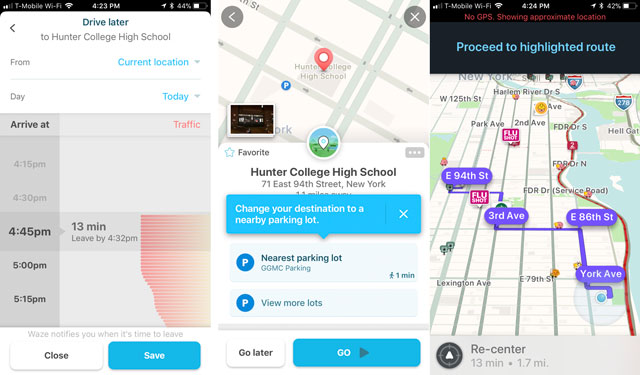
This full-featured navigation app has extra oomph in the traffic alerts department. It crowd-sources traffic information from other drivers using the app, with a friendly map interface that shows icons for accidents, hazards, road closures, speed cameras, and police officers waiting for the next leadfoot to whiz by. Red lines show how long traffic jams extend for, and the app can automatically reroute you to an alternate path.

You can help other Waze users out by reporting nearby traffic conditions, including a handy feature to add a photo and a note about whether the trouble is on your side or the opposite side of the road.

The search function works with places as well as addresses and suggests places based on your location and previous entries. You can also navigate to car services, public transport, restaurants, shops, and more by leveraging Google and Foursquare.

Once you select your destination, Waze comes up with alternate routes you can take and remembers preferred routes after you drive them a few times. And, you can create a Planned Drive by entering the time and date you need to arrive and Waze will recommend the best time to leave. A nice touch: you can send your ETA by email, text, or Whatsapp to your contacts, and sync Facebook and phone calendars so that upcoming events appear in the list of navigation options, including Planned Drives.

  • Turn-by-turn voice directions? Yes
  • Cycle routes? No, driving routes only
  • Traffic reports? Yes
  • Offline maps? No
  • Add stops? Yes

You'll love: Accurate, up-to-date traffic info and good rerouting to get you around severe traffic.

But: Some of the user-submitted info isn't comprehensive or edited (for example, place names might not be capitalized).

Price: Free for Android, iOS on waze.com


Best Offline Maps App: CoPilot GPS

CoPilot

For-pay navigation apps don't have a great case against freebies like Google Maps and Waze -- except when it comes to offline use. A full-fat nav app like CoPilot GPS is a good idea if you're overseas, for instance, and don't want to use roaming data or depend on Wi-Fi stops to update Google Maps.

You'll only need to download maps once -- ideally over Wi-Fi as they're fairly data-heavy -- but once that's done, you can get turn-by-turn voice directions, plan new routes, and use Google-powered search to save new places or addresses for when you're offline. Along with a clear interface showing the next two turns, you get lane guidance for highway driving. And if you end up missing your exit, the rerouting feature quickly gets you back along your way.

The app also logs your speed, with warnings when you're nearing the limit, and shows speed camera locations. Its price tag includes 12 months of ActiveTraffic, which finds the quickest routes based on live traffic info.

  • Turn-by-turn voice directions? Yes
  • Cycle routes? Yes, and walking
  • Traffic reports? Yes, free for 12 months then $9.99/month after
  • Offline maps? Yes
  • Add stops? Yes

You'll love: Excellent search feature for places and addresses; a comprehensive navigation interface that shows ETA, next turns, and overall route; offline use means minimal drain on your smartphone battery.

But: If you don't often drive where you can't access the internet, CoPilot may not offer much more than the free Google Maps.

Price: $9.99 for Android, iOS  and more options on copilotgps.com


Ultimate All-Arounder: Google Maps

Google Maps

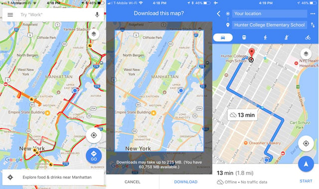
Apple Maps, preloaded on iPhones, may have improved its data accuracy since its wobbly launch, but as a mapping app that still eschews cycling routes, it loses out to Google Maps for everyday navigating.

You open Google Maps to figure out where that bar or restaurant is and tap the navigate icon in the bottom right of the screen to instantly give you a few routes from your current location. You can also tap “Explore Nearby” to see the best user-rated restaurants, bars, and entertainment, along with a filter for how long you're willing to walk or drive to get there. And, you can search within your route for nearby gas stations, coffee shops, restaurants or anything you need and add it to your current route.

The turn-by-turn directions are well-timed, while the search function is top-notch, with auto-suggestions and predictions based on past searches. Once you're on your way, the app continually checks the speed of alternate routes, popping up options to switch to faster ones when they're available.

If you're going to be navigating without a data connection, you can save maps for offline use, complete with voice directions. Maps expire after 30 day, though, so you'll need to make sure you've refreshed your maps if you're going to be without cell service.

  • Turn-by-turn voice directions? Yes
  • Cycle routes? Yes, as well as walking and public transport directions
  • Traffic reports? Yes
  • Offline maps? Yes
  • Add stops? Yes

You'll love: Excellent integration with other Google software. If you use the Chrome browser on your smartphone, you can search for a place, then tap the map result to open it directly in Maps. Android users can mark routes and locations on custom maps in a web browser, save them to My Maps, then access them in the smartphone app.

But: No speed camera warnings.

Price: Free for Android (preloaded), iOS on maps.google.com


Best for the Great Outdoors: Komoot

Komoot

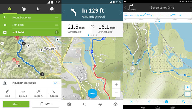
This navigation app covers an exhaustive range of North American bike paths and mountain trails, with topographic maps for hiking and biking routes near you. Its database is built from open-source info as well as user-submitted data to suggest trails for different fitness levels.

Since you're (hopefully) going to be out of radio contact, it's extra handy that the maps and turn-by-turn directions work offline. You can also check out factors like difficulty, surface, elevation, and distance along a particular route. And while navigation, the interface shows your pace plus distance traveled and distance remaining.

The first map (with voice directions) is free; after that, maps cost around $3.99 for one region (basically a city or county); $29.99 for the All-Regions package (which currently includes most of Europe, U.S., Canada, plus some countries in Asia). Updates are free.

  • Turn-by-turn voice directions? Yes
  • Cycle routes? Yes, along with hiking, road biking, and mountain biking
  • Traffic reports? No
  • Offline maps? Yes
  • Add stops? Yes

You'll love: The greater the number of trips you take with Komoot, the better it can recommend trails for your fitness level.

But: The area defined by a Komoot “region” isn't large, so if you're an infrequent hiker, the cost of purchasing extra regions might not make sense.

Price: $3.99 - $29.99. Available for Android & iOS


Best for Road Trips: inRoute Route Planner

inRoute Route Planner

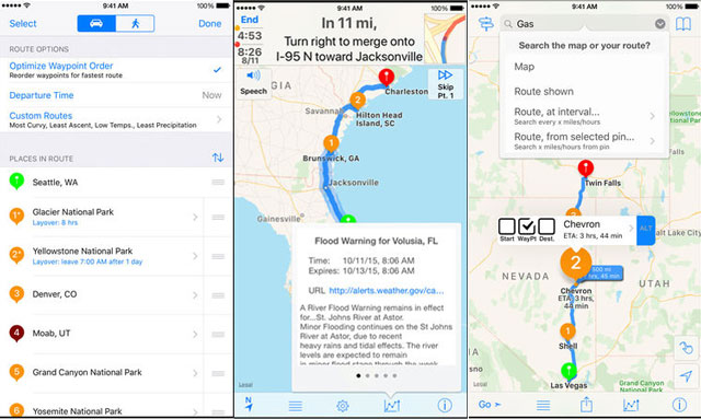
We've used Google Maps to smoothly navigate thousands of miles' worth of road tripping, but when it comes to the planning of a multi-stop, non-direct trip, inRoute has the search giant beat. The free version allows you to plot a route with up to five stops through an intuitive map interface: Drop pins on places you want to go and the app figures out the route. A cool search feature lets you hunt for places of interest such as a gas station or restaurant within a particular distance from you, or at regular intervals along the way.

You can adjust when and where you drive based on extra info gleaned from live-updated weather condition charts, as well as the curviness and elevation of various parts of the route – handy if you're driving an eight-berth RV and want the straightest possible roads (or a motorcycle and want the opposite).

But it's the $14.99 upgrade to Premium that unlocks the real road-trip magic: the ability to add up to 25 stops (or up to 100 stops with Pro for $29.99 every year), along with the amount of time you want to stop in each place, and an optimization feature to reorder your stops into the fastest, most fuel-efficient routes. It's perfect for planning road trips.

  • Turn-by-turn voice directions? Yes, with Premium and Pro upgrades
  • Cycle routes? No
  • Traffic reports? No
  • Offline maps? No

You'll love: Being able to plan a looping route that hits up various destinations before ending up back at your starting point – gas stops, breaks and sleeps included.

But: You have to upgrade to get directions and the app only gives you one route. However, you can export your route to another navigation app, such as Google Maps or CoPilot, if you upgrade.

Price: See above. Available for iOS

Updated on 1/4/2019

[navigation app in car image via Shutterstock]


Topics

Travel, Phones and Mobile, GPS Navigation, Mobile Apps, Travel & Entertainment, Car Tech & Safety, Tips & How-Tos


Discussion loading

gravatar

From Jim on June 01, 2015 :: 10:53 am


My Sprint phone came with Scout for navigation and I’ve used it religiously ever since.  It typically provides several route alternatives, built in traffic reporting and just does a dang good job.

Reply

gravatar

From Cameron Waters on April 21, 2016 :: 6:07 pm


The title basically says it all but curious about this.

Reply

gravatar

From Dave W. on January 22, 2017 :: 3:20 pm


I am not happy with Google Maps that came on my phone so I have been trying others. I tried Scout for a week and I had some bad directions, lots of traffic, including not being able to get back Home! So I uninstalled Scout and am looking again.

Reply

gravatar

From Josh Kirschner on January 22, 2017 :: 4:43 pm


What are you not happy with on Google Maps? I use all the time and have found it to be very easy to use and it’s pretty full featured.

If you don’t like Google Maps, try Waze and see if that is better for you.

Reply

gravatar

From Meilseoir Schwartzthal on October 12, 2017 :: 3:49 pm


Google maps options (based on the parameters included and not included) are missing completely a n Avoid Traffic option for a driver who is not on their way to a deadline/work/appointment. It seems Google Maps sees traffic but with dispassion. It sends you right through the bright red line because “it’s faster.”

Even “avoid highways” doesn’t get the job done. Mostly because the parameters, wanting to make a bee-line, again are magnetized to the highest trafficked roads, and seem blind to obvious routes (that connect a route before and after a downtown, but circumnavigate said downtown) that can be seen on a paper map. GPS has tunnel-vision.

We need a very different app. A traffic avoiding app, allowing the possibilty of finding the least delayed route, not necessarily the “fastest.”

I wish I had the coding knowledge to make such an app. I only have the idea, not the way to make it happen.

As far as parameter behavior goes, I imagine something like a taxi meter that charges $0.01 per mile, but $10.00 per minute, guaranteeing that the program wants to avoid wait time, not avoid longer mileage or overall longer time.

It wouldn’t replace traditional GPS or “fail” as a “good” GPS, but offer an alternative TO them.

gravatar

From Orvar Lyckholm on July 18, 2019 :: 5:30 pm


It works all right in most cases, but read “the small print”. When you use it data is sent to Google. That is how they make money:
Give away an app for free—spy on the user—sell the information.
If that is OK for you, fine. I prefer an app that is totally free from any “call home” parts. Have a look at my favourite: Magic Earth. All permissions it needs is access to the GPS receiver and storage (to store the maps you download). That´s it.

gravatar

From Giovanni Mario on December 01, 2019 :: 9:54 am


Google Maps Sucks, It always takek back roads, and thwer is no way to cghange that into as major highway only.
Results in longer trips than planned!

gravatar

From Susie on March 26, 2020 :: 7:48 am


Because Google shares your location info with poluce ! Need I say more ?
Even if you are innocent you can be a suspect simply because you were nearby !

gravatar

From Josh Kirschner on March 26, 2020 :: 8:50 am


Susie, I know of no instances of Google sharing location information with law enforcement without a warrant. If you have a reference for that claim, please share it.

That stands in stark contrast to the cellphone carriers, who had been (and perhaps still are) selling our location data to law enforcement, as well as almost anyone who desired access, with basically no controls.

gravatar

From Ronald B. on March 01, 2021 :: 7:10 am


I have used Google Maps for years. I have seen Google Maps miss obvious shorter(time and distance!) routes plus Google has on more than one occasion told me to turn (right or left in different places) where there is (and never was) a road to turn onto! I don’t understand how that occurred, but I did send those to Google. I have an actual windshield mounted GPS (I know! Old school!) and I was using it in conjunction with Google maps. The GPS beat Google Maps more than a few times. Also,I like how the GPS will show the name of the next road/street, but Google Maps does not if that road or street is not associated to my routes. There are times when I know a shorter route that Google doesn’t advise me of because I know there will be a traffic jam, but sometimes forget the name of the road until I see it. A quick look at the GPS and I see the upcoming road name and know that particular road is coming up.

I am now trying Apple Maps and I am not impressed with that.

gravatar

From Roseanne Braverman on July 03, 2021 :: 1:41 pm


I was recently in Albany NY and both Google Maps and the iPhone app were terrible.  Both had me driving in circles around the hotel I booked, when the entrance was off the main road.  And iPhone sent me 18 miles in the wrong direction to get on 87south, when the correct exit would if been to go left instead of right when the highway split.  Crazy and frustrating!  The whole weekend was like that.  My nephew lived in a rural area and all the routes chosen were long and indirect.  I never had such a hard time with navigation before.

gravatar

From Elorea on November 01, 2021 :: 3:08 pm


I’d love to see a paid navigation app that DOES NOT have ads. If you don’t like/trust Google Maps DO NOT use Waze. Waze is owned by Google.

gravatar

From Andrea Macario on June 02, 2015 :: 4:14 am


hi, thanks for the article. what do you make of HERE? (disclaimer, I used to work for them a few years back). they have offline maps for all over the world with turn by turn navigation, traffic, walk, public transport, places information and other stuff and they are actually entirely free to use both in online and offline mode.

Reply

gravatar

From Edgar Chimal on November 16, 2016 :: 12:11 am


I’ve using HERE maps (formerly Nokia Maps) since it only existed in Symbian.

Reply

gravatar

From Don Albert on December 11, 2015 :: 11:48 am


I’ve been using the ‘Here’ maps for two phones now. First it came installed on my Nokia Lumia 520, when I upgraded to the Nokia 1020 I had to update them - it took a while, but well worth it. Love the HERE maps/GPS system.

Reply

gravatar

From Xaver on December 16, 2015 :: 8:55 am


Hi, I would say you did not use those apps what so ever or just didn’t compare with standalone navigations. You missed one but important issue. They are not so fast. Yes waze is good for trafic jams but the app is so slow. If you dont know the road and you depend on navigation waze will tell you to turn way after you pass the turn. Here is not speaking properly. Sometimes the voice guide is on cofee brake.

Reply

gravatar

From Francis Hofer on March 31, 2016 :: 2:51 pm


I’ve been mapping since before there were map app (mapps?). These mobile maps have changed the outside sales game. I used to have to physically map my routes the night before and had to struggle through creating the fastest routes to all my points. Optimization wasn’t the only issue, but also traffic. The opportunity cost of two hours spent in LA traffic is unimaginable. Mobile apps have completely solved both my issues. I use Badger Maps and Waze (which are integrated, thank the lord) to optimize and then route my daily trips. Google Maps is on the list and is clearly the leader of the map app (again, can we make ‘mapp’ a thing?) game, but it is just too general for my use. I need to visit 20 places in a day in the most efficient way and avoid traffic getting there. Glad to see that Waze is at the top of the list.

Reply

gravatar

From Cameron Waters on April 21, 2016 :: 6:05 pm


I’m using them for outside sales too but I’m using google maps. Cool that there are options.

Reply

gravatar

From Lori on July 07, 2016 :: 3:27 pm


Thoughts on HERE? They do maps for most auto nav systems on the market and are ranked by the auto industry as the best quality?

Reply

gravatar

From Cai on July 22, 2016 :: 7:02 pm


Does anyone know of an app that shows block or house numbers? I really need one for work.

Reply

gravatar

From JP on December 10, 2016 :: 6:16 pm


Here shows house address numbers if you zoom in and use satalite.

Reply

gravatar

From James Formolo on October 22, 2016 :: 7:02 pm


You stated that one needed to export maps created in inRoutes to Google Maps in order to navigate the custom map.  That is incorrect.  Google Maps does not have the capability to navigate custom maps - it can only display them.

Reply

gravatar

From antonio on February 04, 2017 :: 11:09 am


what about here maps/here we go.
this app is wonderful it came pre-installed on my windows 8 smartphone. i switched to android & the first thing i did was go to play store & download it.

Reply

gravatar

From CAOutdoorGir1 on June 27, 2017 :: 10:51 am


I’ve been using Waze for nearly five years, and it just keeps getting better. Besides what was mentioned, it also allows you to report gas station prices, gives you the speed limit and whether you’re going under or over, quickly reroutes you when you miss a turn, and allows you to take pictures of the street view of a place so you know when you’ve arrived.

It did used to have an add-a-stop feature, which was handy but could be clunky. Rather than improving it, they scrapped it altogether.

Since this app is crowdsourced, if there’s a new street just opened, you can “pave it” on the map by pressing Pave and just driving down it.

Though there’s no “left lane closed” button, you can use the construction function and type it in. It seems like this app has it all.

Except now it added ads. Easily dealt with, though—tap the screen (not on the ad), and it goes away.

Reply

gravatar

From katka on August 03, 2017 :: 9:23 am


Hi, I use Google Maps when I have good data connection. But often I need to plan my route in advance or navigate offline and use rather Mapfactor Navigator.

Reply

gravatar

From Ariane on August 30, 2017 :: 8:26 pm


That is all

Reply

gravatar

From Bruce Brodnax on September 24, 2017 :: 2:02 am


...it’s a data gobbler. Before you use it, you’d better double whatever data rate you’re subscribed at, and be ready to bump it up when your carrier gives you a “you’re nearing your limit” warning. Unless you’ve got unlimited data, in which case, go to town!

Reply

gravatar

From Ariane on September 24, 2017 :: 4:46 pm


I have a 40 gigabyte monthly data plan :D

Reply

gravatar

From Angelina Brino Robertson on December 26, 2018 :: 7:46 pm


None of these app give the option to customize your route. Sometimes the fastest route is not what is closest to me. I just want one where i can drag the route (like on mapquest for pc) so i can get exact miles. I have to write down my miles every day and when i forget one stop i cam never get the exact way i went. Always some other route
Any options out there for customising routes?

Reply

gravatar

From Suzanne Kantra on December 27, 2018 :: 11:32 am


If you use Google Maps on your laptop, you can drag and drop your route. Click anywhere on the bright blue path to set a point and then drag it to the turn you want to take. Google Maps will automatically snap it to roads, so you just have to set the turns.

Reply

gravatar

From Josh Kirschner on December 27, 2018 :: 12:38 pm


It’s not as clean as you would like, but you can set waypoints along the route to your destination, and customize those waypoints to force the app to route you the way you want (or at least very close to it). Depending on how much your desired route differs from the calculated route, you may only need to add one or two waypoints.

Reply

gravatar

From Ariane on January 12, 2019 :: 11:36 am


You can set pins (waypoints) and if you took an alternative route from one point to another you can set another pin along the route you took to get the miles. I am a truck driver and I use it like this all the time!

Reply

gravatar

From Lightgate Weaver on January 04, 2019 :: 5:29 pm


I’ve been using Sygic for Android for several years, as have my family and several friends. We’ve all been very pleased with its features and the number of map updates and program enhancements that are issues each year.

Reply

gravatar

From Meilseoir Schwartzthal on July 01, 2019 :: 8:21 am


I have found myself drifting away from Google maps for mobile navigation (even though it is still there on my phone) and instead find myself opening up Sygic by habit, most, if not nearly all of the time. I think now, I usually only use Google on a desktop pre-trip.

Reply

gravatar

From GB Radio on March 11, 2019 :: 9:55 pm


This website is absolute usless. Using this app I actually had to get out the atlas. Won’t even tell distance to stops or starts borders. Don’t waste your time, download a better app. Don’t want to get lost in the applications using this pos app. Would have been nice to know the three state lolive was 5 miles rather than than what looked like 30. F you Google maps!

Reply

gravatar

From Lynda Locke on March 17, 2019 :: 7:09 pm


I frequently travel to the Williamsburg, Va. area from the Richmond area. Every navigation app I’ve used routes me on Interstate 64 which I HATE. Traffic is always awful as this is the main route to Va beach. I prefer Rt. 60 which usually has little traffic and is just a more pleasant route. Problem is all the way down 60 navigation is constantly trying to reroute me to 64.  On Mapquest for PC I used to be able to click on 64 and tell it to avoid 64 and I would be routed to 60 or 5.  Is there a GPS app that let’s you avoid certain specific roads?  Telling it to avoid highways doesn’t work as part of my return route does require highways.
I like using GPS even when I k ow the route for traffic and speed.

Reply

gravatar

From Antonio Robinson on March 17, 2019 :: 10:50 pm


hi Lynda Locke
have you tried HereMaps. on android it’s called here we go app. i also like INRIX traffic app. good luck
let me know how it works out

Reply

gravatar

From Lindsay on March 25, 2019 :: 12:54 am


Are there any privacy friendly digital mapping apps in terms of the least amount, if not none altogether of collecting, storing, sharing, and selling of personal data analytics? At which if not, why hasn’t any privacy conscious minded team of software developers filled that niche of the gaining desire of the digital privacy paired with digital mapping/navigation market? Seems like a wonderful software startup company with a lot of growth ahead of them.

Reply

gravatar

From James on May 05, 2019 :: 11:20 am


I was about to install Waze - then saw what they wanted: access to my Identity, Calendar, Contacts, Location, Photos/Media/Files, Camera, Microphone, and Bluetooth connection information ... Un-freakin’-believable!  People actually give them all this?!

Reply

gravatar

From Josh Kirschner on May 06, 2019 :: 9:36 am


Most of what you’re describing makes complete sense for this type of app. Obviously, it needs your location to navigate, microphone allows voice entry of destinations, Bluetooth connects with Android auto, contacts allows you to navigate to a friend’s address, calendar provides autonavigation to your calendar appointments, photos so you can add a personal photo as your account image.

It’s important to note, though, that the ONLY app permission that is active for Waze on install is Location. All the others you have to give permission to manually. And, if you ever wanted to revoke any permission you’ve granted (for Waze or any other app), it’s easy to do through Android App permissions.

Reply

gravatar

From David L on July 03, 2019 :: 7:21 am


Google maps can’t “find” me about 80% of the time. It will automatically put me on toll roads. You must find the Avoid Tolls button which is well hidden compared to buttons you use far less frequently.  There is no pause button so if you decide to make a stop for gas, you are bombarded with “make a U turn”, “in 1/4 mile turn left”, etc. Makes me turn it off! Poor product. A magnetized pin on a floating leaf is better!

Reply

gravatar

From Josh Kirschner on July 03, 2019 :: 1:08 pm


I’ve used Google Maps for years on numerous phones and never had a issue with location tracking. If you are experiencing this, it likely is due to a problem with your phone’s GPS or location settings, or you’re in an area that has poor line-of-site to satellites (heavily wooded, mountainous, etc.).

Maps can be set to avoid tolls for all trips in Settings > Navigation and can be changed for individual trips by pulling up Settings within that trip’s menu. That seems pretty simple to me for a function that should rarely change once set. I agree with you about the pause button. But, again, it’s pretty simple to temporarily exit nav and go right back in to your trip when you’re ready within the app.

All in, if you think a magnet on a floating leaf is better, you must have a pretty special floating leaf!

Reply

gravatar

From Orvar Lyckholm on July 18, 2019 :: 5:26 pm


Just test Magic Earth. I found it by accident a month ago and it immediately became my standard offline navigation app. Both Android and iOS.
Completely free, and no ads. The company makes money off another product. Car, bike, pedestrian and puclic transport.
Turn by turn directions, cycle and walking routes, traffic reports online, offline maps (unlimited number), and it is super easy to add stops. HUD if you want that in the dark, both recorded voices and text-to-speach with street names et.c.
Easy to set both start and end points and get a test drive at 1 - 10 x speed. In short: All you need for driving a car or bike, walking and using public transport. (The latter is of course dependent on wether your local transportation companies share the info or not.) I have tested it in Sweden, Denmark, Germany and the Netherlands, and it has never failed. Plotting a 1250 km route from our company (Valutronic) in Gothenburg to a camping site in the Netherlands is done in less than 10 seconds. I simply love this app!

Reply

gravatar

From t.daniel on November 07, 2019 :: 8:56 pm


what does add driving shortcut suppose to do on gps

Reply

gravatar

From Aja Raye on November 09, 2019 :: 1:58 am


I have used Google Maps for the Timeline and Sharing features. Timeline history for work expense and activity reports and Sharing in the event I have car trouble. For the most part, my husband could find me if there was an accident or other safety need.
Timeline quit with the last update and the other features are not so great I want to keep using Google Maps. Plus, the last update added restaurant, etc. buttons to the screen and it’s cluttered.
Several apps listed by other commentors are worth trying out. Thank you for the tips.

Reply

gravatar

From Mohammed Al-Tahami on August 08, 2020 :: 5:36 am


Can any one help me writing a free ios app which draw a path on a map and save it in app history so i can drive back the same path.

Reply

gravatar

From TomTom Map Updates on March 15, 2021 :: 6:28 am


TomTom always provides the software and map update to their users but due to lack of right information, users didn’t find the accurate steps and due to update,. Tomtom Map Update TomTom GpsUpdate users got plenty of issues such as network issue, wireless and Bluetooth connectivity issue, hanging problem, the screen is showing unexpected error and much more

Reply

gravatar

From Spunky on February 03, 2024 :: 4:00 pm


I find that Google maps has taken me through some very odd side roads and once even led me to a county road across a state that I had never been through. This is puzzling and provokes anxiety. Why should I risk getting lost or stuck in an out out of the way location where it would be difficult to explain to someone how to get to where i am so I can receive assistance? It’s one reason why I’m looking for a better app. To me it’s been unreliable. Nevertheless, the options aren’t substantially better. What to do? Lost…

Reply

Home | About | Meet the Team | Contact Us
Media Kit | Newsletter Sponsorships | Licensing & Permissions
Accessibility Statement
Terms of Use | Privacy & Cookie Policy

Techlicious participates in affiliate programs, including the Amazon Services LLC Associates Program, which provide a small commission from some, but not all, of the "click-thru to buy" links contained in our articles. These click-thru links are determined after the article has been written, based on price and product availability — the commissions do not impact our choice of recommended product, nor the price you pay. When you use these links, you help support our ongoing editorial mission to provide you with the best product recommendations.

© Techlicious LLC.